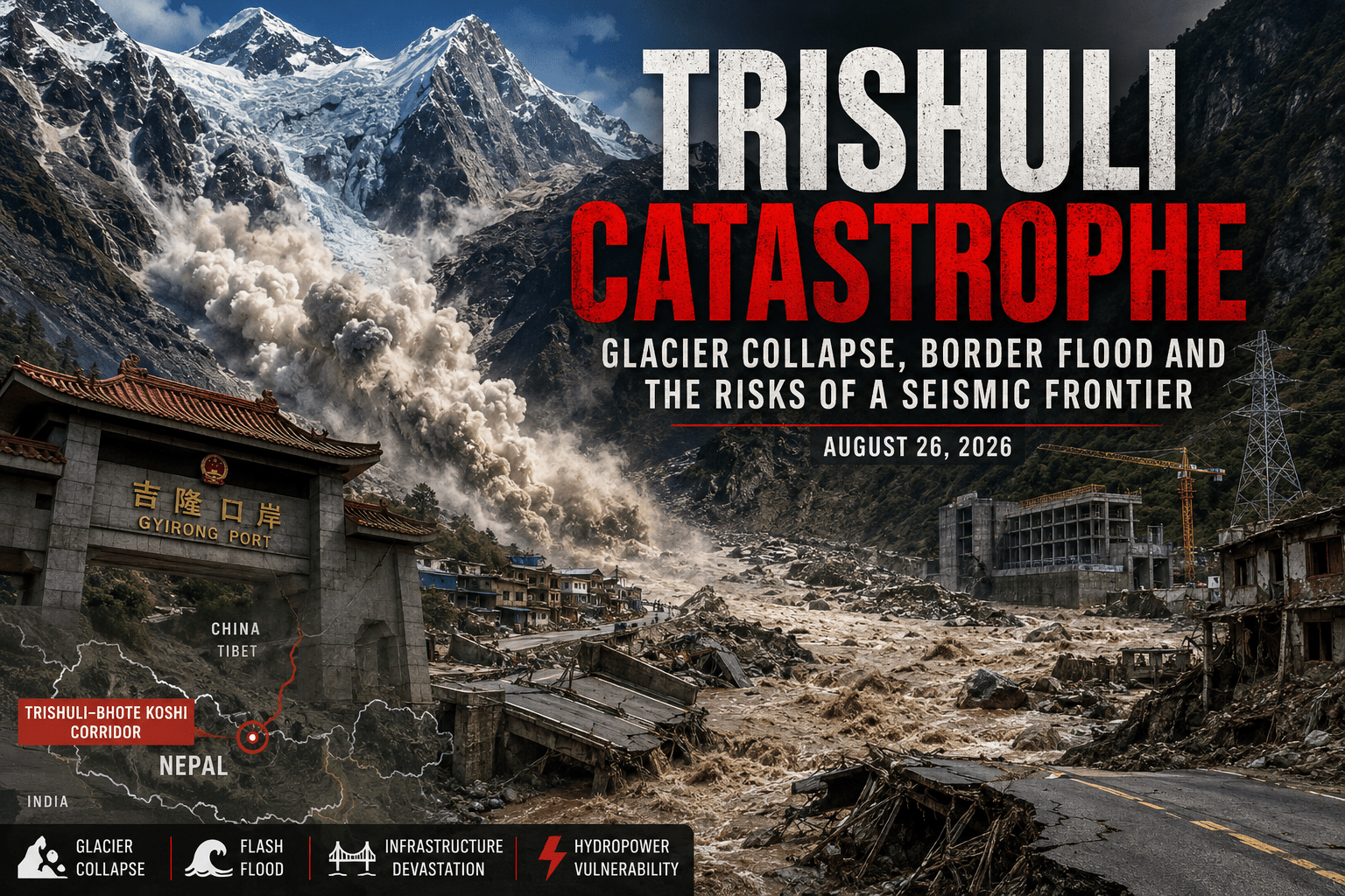
An investigative overview of the August 26, 2026 disaster along the Nepal-China border
Executive Summary
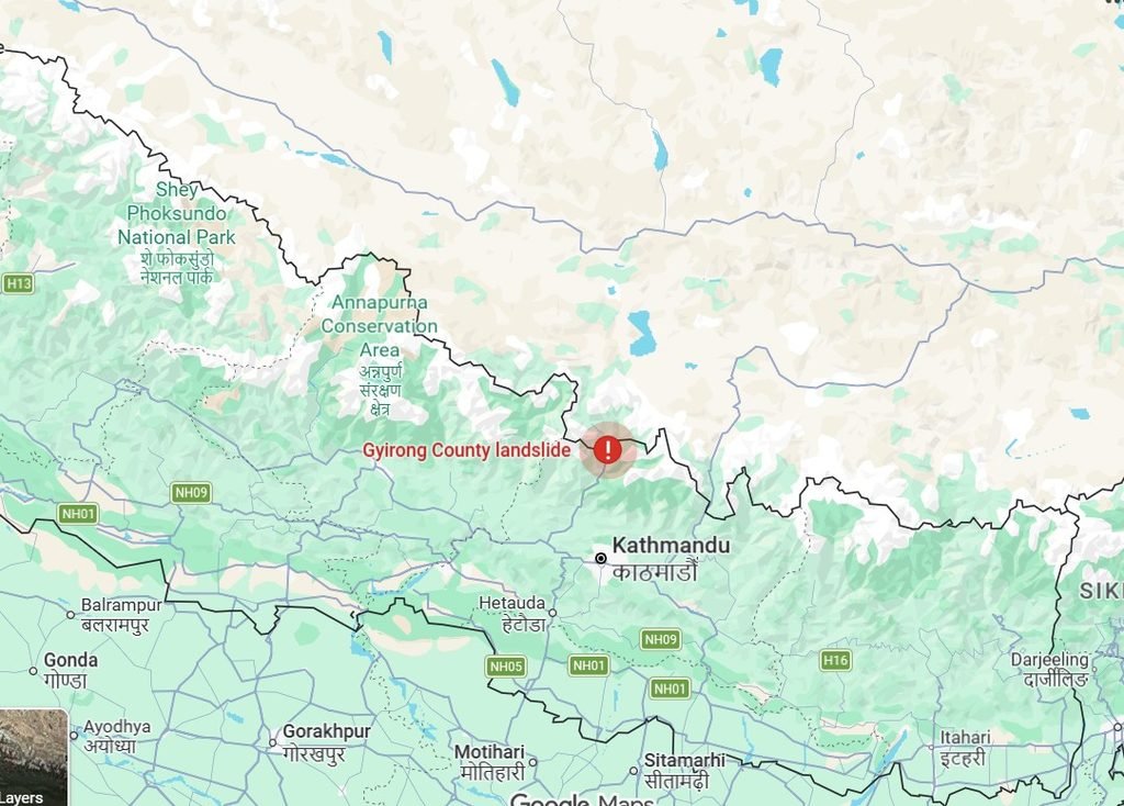
On the morning of August 26, 2026, a catastrophic surge of water, ice, rock, and debris swept through the Himalayan valleys along the Nepal-China border. The disaster devastated communities and infrastructure in Nepal’s Rasuwa and Nuwakot districts and affected China’s Gyirong County and the Gyirong Port border crossing.
The flood destroyed or severely damaged roads, bridges, power infrastructure, homes, and commercial facilities. It also disrupted an important trade and tourism corridor connecting Nepal and Tibet. By August 27, hundreds of people had been confirmed dead and more than a thousand remained missing, with figures still changing as rescue operations continued. Reuters reported at least 270 dead by August 27; the Associated Press later put the combined toll at more than 390 dead and 1,400 missing across Nepal and China.
The initial explanation focused on an earthquake and avalanche. That interpretation changed quickly. The US Geological Survey subsequently determined that the seismic signal initially interpreted as an earthquake was actually generated by a large glacial collapse and debris flow. Independent reporting and scientific assessments have likewise pointed to an ice and rock avalanche originating in high altitude terrain.
The evidence currently available does not show that an existing hydropower dam caused the initial disaster. The triggering event appears to have occurred in unstable glacial and mountainous terrain. The more important question concerns vulnerability.
The Trishuli and Bhote Koshi corridors contain extensive hydropower infrastructure, roads, bridges, and border facilities in an environment defined by steep terrain, active tectonics, landslides, glacier instability, and rapidly changing climatic conditions. Several projects have Chinese financing or construction involvement. The disaster therefore raises a broader question: is critical infrastructure being concentrated in a landscape where natural hazards can move rapidly from remote mountain slopes into densely developed river valleys?
This is not simply a debate about China or hydropower. It is a question of how Nepal, China, and other Himalayan states assess infrastructure risk in a region where geological and climatic hazards increasingly overlap.
Part I: What Happened
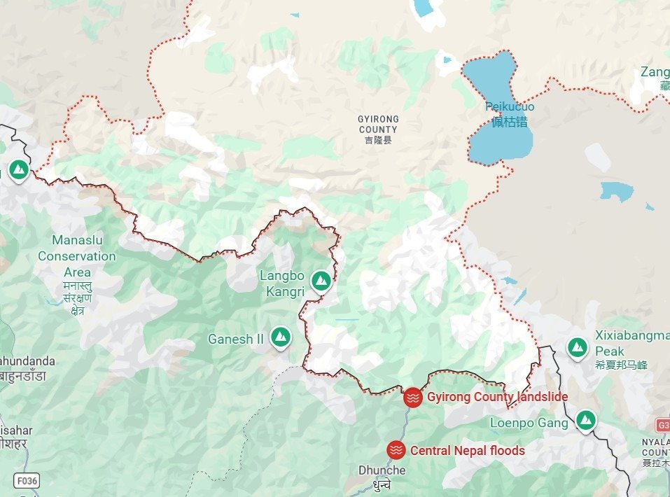
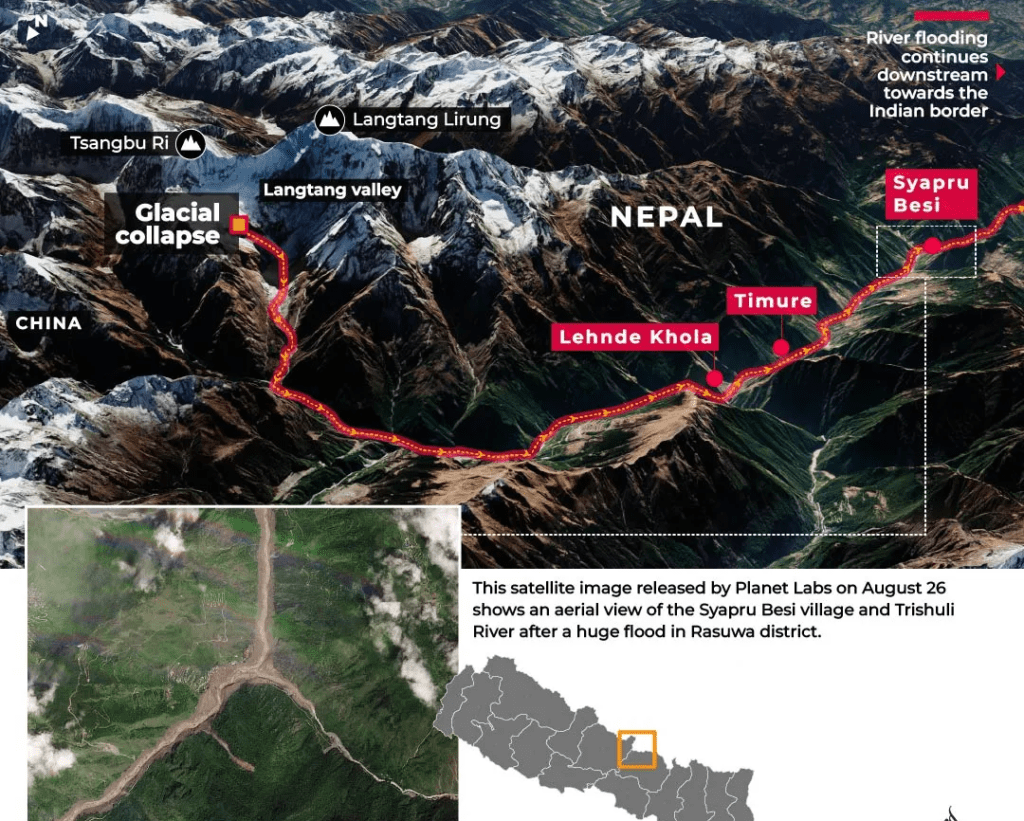
The disaster struck the Trishuli river system on August 26. The affected area includes the Bhote Koshi and other tributaries that originate in the high Himalayas before flowing through Nepal toward the Gandak river system and eventually into India.
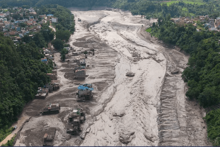
The speed and destructive power of the event were extraordinary. Floodwaters carrying enormous quantities of sediment, ice, and rock moved through narrow valleys where settlements, roads, bridges, power facilities, and commercial infrastructure had been built close to the river channels.
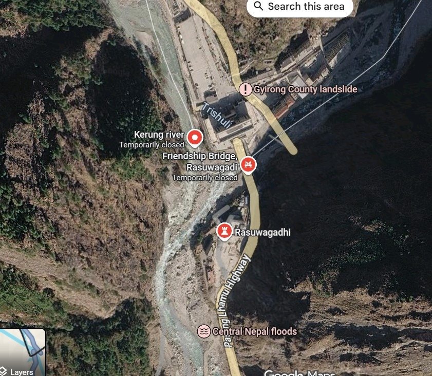
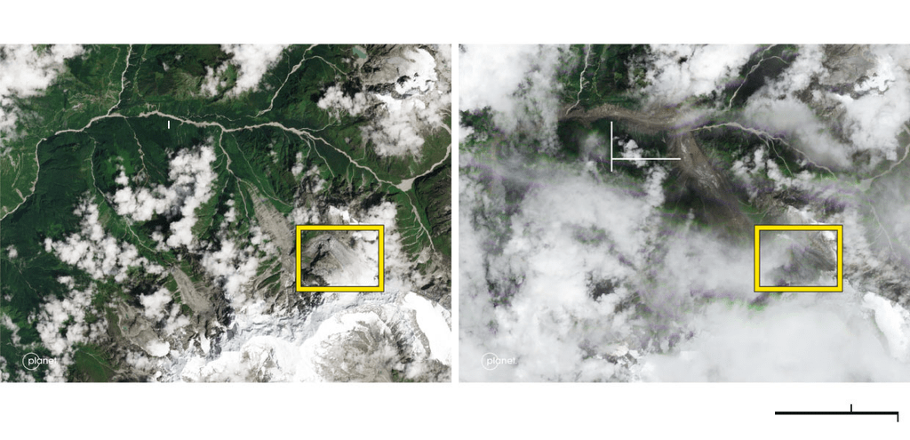
Satellite imagery and ground reports showed extensive destruction on both sides of the international border. Gyirong Port, an important China-Nepal trade crossing, was badly affected, while settlements and infrastructure in Nepal were buried under mud and debris.
The disaster also hit a region heavily used by tourists, pilgrims, traders, and workers. Hundreds of foreign nationals were among those reported missing during the initial rescue operation.
The scale of the event was made worse by the geography. Himalayan valleys act as natural channels that concentrate enormous volumes of water and debris into relatively narrow corridors. Once a large mass begins moving downslope, the destructive energy can travel considerable distances.
From Earthquake Theory to Glacier Collapse
The first explanations focused on seismic activity. Early reports suggested an earthquake may have triggered an avalanche or landslide, and a seismic signal detected in connection with the disaster led to an initial interpretation that an earthquake had occurred.
That interpretation was later revised. The USGS determined the seismic signal was generated by the collapse of glacial ice and rock and the resulting debris movement, not by a conventional earthquake. Reuters reported that experts were also examining the possibility that an ice-rock avalanche initiated the flood.
This distinction matters. An earthquake-triggered landslide and a glacier collapse can produce similar downstream consequences, but they carry different implications for monitoring and early warning. A conventional earthquake can often be detected and located almost immediately through established seismic networks. A sudden collapse of glacial material presents a different monitoring challenge, particularly in remote, high altitude terrain.
Current evidence points toward a sequence involving glacial instability, an ice and rock collapse, rapid movement of debris, and a catastrophic downstream flood or debris flow. The precise mechanics continue to be investigated.
Part II: A Second Hazard Emerges
The initial flood was not the only danger. The movement of rock, ice, and sediment also altered the river system and created conditions for a temporary landslide-dammed lake, sometimes called a barrier lake.
Such formations can be extremely dangerous because a natural dam made from loose rock and debris may fail suddenly. If water accumulates behind it and the barrier collapses, a second flood wave can move downstream with little warning.
Chinese authorities warned of continued flood risk in the affected area and reported that substantial quantities of water had accumulated behind a newly formed natural barrier near where Nepal’s Chhochen Khola meets the Purepu Tsangpo, which flows into China.
This type of hazard has historical precedent across the Himalayas and the Tibetan Plateau. Natural landslide dams have repeatedly formed after earthquakes, landslides, and glacier-related events. Some have remained stable for extended periods. Others have failed suddenly, releasing large volumes of water downstream. The danger is most serious when settlements and infrastructure sit below the natural barrier.
In this respect, the 2026 disaster is not simply a flood story. It is also a story about the ability of Himalayan terrain to create temporary dams without any human intervention at all.
Part III: A Corridor With a History of Disasters
The August 2026 catastrophe did not occur in isolation. The Nepal-China border region has experienced repeated floods, landslides, glacial lake outburst floods, and earthquake-related disasters.
July 2025, the Purepu and Lhende flood. A glacial lake-related flood originating in Tibet swept toward the Nepal border, destroying the Friendship Bridge at Rasuwagadhi and causing extensive damage to roads, vehicles, and hydropower infrastructure, including the 111 MW Rasuwagadhi Hydropower Project, the 60 MW Trishuli 3A plant, the 21 MW Trishuli plant, and the 15 MW Devighat plant, cutting roughly 200 MW of generation. The 2026 disaster was even more destructive, and together the two events show that this river system does not recognize the political boundary between Nepal and China. A hazard originating in one country can quickly produce consequences in the other.
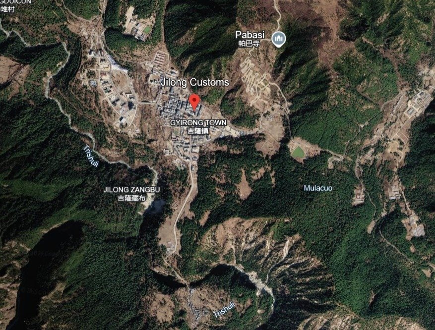
April 2015, the Gorkha earthquake. The magnitude 7.8 earthquake killed almost 9,000 people and triggered extensive landslides throughout Nepal and adjoining Himalayan areas. It also damaged hydropower infrastructure in the Trishuli region, including serious damage to tunnel works at the Upper Trishuli 3A project. The same earthquake triggered the Chongsecun landslide just across the border in Tibet, which dammed the Gyirong Zangbo River and formed a lake threatening both countries, a direct historical precedent for the type of cross-border landslide-dam hazard seen again in 2026.
2000, the Yigong landslide. Farther east on the Tibetan Plateau, a massive landslide created a natural dam on the Yigong River. Its eventual failure produced a major downstream flood and became an important case study in Himalayan landslide-dam hazards.
2018, the Baige landslides. Landslides blocked the Jinsha River in Tibet and created major temporary lakes, forcing large-scale evacuations as authorities worked to manage the risk of sudden dam failure.
These events show why natural dams are considered among the hardest hazards to predict. The initial landslide may be impossible to prevent, while the timing and mechanism of the eventual breach can remain uncertain for weeks.
Part IV: The Hydropower Question
The Trishuli and Bhote Koshi corridor is not an empty wilderness. It has become an important center of hydropower development. Nepal has invested heavily in hydropower to expand domestic electricity generation and grow electricity exports, and Chinese companies and financing have played a significant role in several projects, including power stations, substations, transmission facilities, access roads, and construction sites. That concentration creates both economic opportunity and vulnerability.
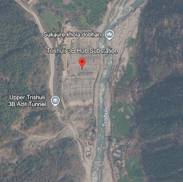
Upper Trishuli 3B. This project and its associated transmission infrastructure form part of the expanding electricity network in the region and have involved Chinese contractors, including the substation infrastructure. The 2026 disaster affected hydropower infrastructure in the corridor, adding to damage from previous natural disasters.
Upper Trishuli 3A. Financed with Chinese support and inaugurated in 2019, this project’s history is particularly relevant because it was already damaged by the 2015 earthquake and again in the 2025 flood, illustrating that the vulnerability of hydropower infrastructure in this specific basin is not a new concern.
Super Trishuli. Another hydropower development in the wider Trishuli system, originally associated with Chinese construction involvement before the 2015 earthquake, though subsequent project arrangements changed. Development in the region has continued despite repeated evidence of geological instability.
Older facilities. The vulnerability is not limited to Chinese-backed projects. Older Nepali hydropower facilities have also suffered earthquake and flood damage. This distinction matters: the physical risk comes from the environment the infrastructure sits in. Chinese financing or construction can be an important part of the story, but it does not by itself explain why the infrastructure is vulnerable. The central issue is risk concentration, not simply national ownership.
Part V: Did the Dams Cause the Flood?
This is the most important question for assessing the disaster accurately, and the evidence currently available does not establish that an existing hydropower dam triggered the August 2026 disaster.
The USGS assessment points to a glacial collapse and debris flow as the initiating event. Reuters and other outlets have similarly described an ice and rock avalanche as the likely trigger. The initial failure therefore appears to have occurred in the high mountains rather than at an engineered hydropower facility, and that distinction should be maintained. It would be misleading to claim that Chinese-built dams caused the flood without evidence demonstrating such a connection.
A different question remains, however: did infrastructure increase the consequences? Here the picture is more complicated. Hydropower facilities, roads, bridges, and settlements occupy the same narrow valleys through which floodwaters and debris naturally move. When an extreme event occurs, infrastructure located within the hazard corridor can be damaged or destroyed, and that is exactly what happened here. Power infrastructure was affected, roads and bridges were destroyed, border facilities were damaged, and communities near the river were overwhelmed. Infrastructure can become part of a disaster’s consequences even when it is not the cause, and that distinction is central to understanding the Trishuli catastrophe.
Part VI: The Chinese Hydropower Dimension
China’s role deserves scrutiny because Chinese companies and financing are involved in significant infrastructure projects across the Himalayan region, but that scrutiny needs to rest on evidence rather than assumption.
Chinese hydropower development extends well beyond the Trishuli basin, across the Tibetan Plateau and the upper reaches of major Himalayan river systems. These projects have raised concerns in neighboring countries about seismic risk, downstream water security, transparency, and the lack of detailed information about dam operations. The planned Medog hydropower project on the Yarlung Tsangpo has attracted particular international attention because of its enormous projected scale and its location in a highly tectonic region.
The relevance to the Trishuli disaster is not that the Medog project caused the 2026 flood; there is no evidence for that. The relevance is that both cases raise the same underlying question: how should governments assess the long-term safety of very large infrastructure projects in an environment where earthquakes, landslides, glacier instability, and extreme floods can interact? That is a legitimate engineering and policy question regardless of whether a project is Chinese, Nepali, Indian, or financed by another country.
Part VII: Climate Change Adds Another Layer of Risk
Geology alone does not explain the growing concern. The Himalayan cryosphere is changing. Glaciers are retreating, snow and ice conditions are shifting, and high altitude landscapes are becoming increasingly unstable in some areas. Scientists have repeatedly warned that warming temperatures contribute to glacier retreat, the formation or expansion of glacial lakes, and changes in mountain slope stability.
The 2026 disaster has renewed attention to this problem. Reuters reported that scientists investigating the event were examining the role of climate change in creating the conditions that may have destabilized Himalayan ice and rock. That does not mean climate change alone caused the disaster; mountain disasters usually involve multiple interacting factors. A possible sequence looks like this:
- Long-term warming and glacier retreat.
- Changes in snow and ice stability.
- Destabilization of rock surrounding or beneath glaciers.
- A sudden collapse or avalanche.
- River blockage or direct debris flow.
- Rapid downstream flooding.
- Destruction of infrastructure located in the river corridor.
The August 2026 disaster appears to fit several elements of this broader hazard chain, though the exact sequence remains under scientific investigation.
Part VIII: Why Early Warning Is So Difficult
One of the hardest aspects of Himalayan disaster management is the enormous distance between the hazard source and the communities at risk. A collapse can occur in a remote mountain area with few instruments, limited communications, and difficult access. By the time a flood or debris flow becomes visible downstream, communities may have only minutes to respond.
Traditional flood-warning systems are not always sufficient for high altitude landslide and glacier related events. A rainfall monitoring station may not detect an ice-rock avalanche. A river gauge may only detect an abnormal rise after the event has already begun. A seismic network may detect unusual ground motion but initially struggle to distinguish between an earthquake and a large landslide or glacial collapse.
This creates a difficult policy problem: the region needs monitoring systems capable of detecting multiple hazards at once, rather than treating earthquakes, floods, landslides, and glacier events as separate categories.
Part IX: What the Disaster Says About Infrastructure Planning
The central lesson from the Trishuli catastrophe is not that hydropower should necessarily stop. Nepal has a real need for reliable electricity, and hydropower remains one of the country’s most important domestic energy resources and a major potential source of export revenue. The question is where and how infrastructure should be built.
A project may be technically safe under normal conditions and still be exposed to extreme hazards outside the assumptions used during its design. A dam can survive a flood while the road providing access to it is destroyed. A power station can remain structurally intact while its transmission substation is buried. A bridge can be engineered to withstand river flow but fail when struck by enormous quantities of rock and debris. A hydropower project can remain structurally sound while the infrastructure required to operate it becomes unusable. This is why disaster planning has to consider the entire infrastructure network, not just individual facilities.
Part X: The Transboundary Problem
The Nepal-China border adds another layer of complexity. The rivers crossing the region connect landscapes under different governments. A glacier collapse in Tibet can affect Nepal. A landslide in Nepal can affect Tibet. A natural dam can form on one side of the border and threaten communities on the other, and infrastructure decisions made upstream can have consequences downstream.
This makes information sharing essential. Nepal and China need mechanisms for rapid exchange of information concerning glacier instability, glacial lakes, landslide dams, abnormal river levels, earthquakes, hydropower infrastructure, emergency releases, cross-border evacuation, and satellite observations. The 2026 disaster shows why disaster preparedness cannot stop at the international boundary.
Part XI: The Real Investigative Question
The evidence available today does not support a simple narrative that Chinese dams caused the Trishuli disaster. It points instead toward a natural high altitude collapse that produced a catastrophic flood and debris flow.
Stopping the investigation there would miss the larger issue, though. The real question is whether governments have adequately accounted for the consequences of concentrating critical infrastructure in a landscape where multiple hazards can interact. The Trishuli corridor has already experienced earthquakes, landslides, floods, and glacier related events, and the region has also seen rapid infrastructure expansion. Those two developments are now intersecting. That does not mean infrastructure development caused the natural hazards. It means infrastructure planning must account for them.
Conclusion: A Warning From the Himalayas
The August 2026 Trishuli catastrophe is a stark reminder that the Himalayan environment remains capable of producing disasters on a scale that can overwhelm even major infrastructure networks. The immediate trigger appears to have been a glacial collapse and associated ice-rock debris movement rather than the failure of an existing hydropower dam. That finding should prevent premature claims about the role of dams in causing the disaster.
At the same time, the destruction of hydropower, transport, and border infrastructure shows the vulnerability created when critical assets are concentrated along narrow Himalayan valleys. The issue is not simply whether China is building dams, or whether Nepal needs hydropower. The larger issue is whether the current model of Himalayan infrastructure development adequately accounts for a landscape undergoing simultaneous geological and climatic change.
The mountains are changing. Glaciers are changing. River systems are changing. The frequency and character of extreme events are becoming harder to predict. Infrastructure planning has to change with them.
The Trishuli disaster should be treated not merely as a tragedy to be followed by reconstruction, but as a warning about the limits of conventional infrastructure planning in one of the world’s most hazardous mountain environments. The key question for Nepal, China, and other Himalayan states is no longer simply what caused the flood. It is whether the next disaster will find critical infrastructure, and the people who depend on it, better prepared than it was this time.
In Memory and Solidarity
Behind every figure in this report is a person, a family, a home, a livelihood. Hundreds have died and well over a thousand remain missing across Nepal and Tibet, among them children, parents, pilgrims, traders, and workers who were simply going about their lives when the mountain gave way. Our thoughts and prayers are with the victims, the missing, and their loved ones, and with the rescue workers, medical staff, and volunteers on both sides of the border working under exhausting and dangerous conditions to find survivors and bring some measure of comfort to the grieving. May the dead be remembered, may the missing be found, and may the communities of Rasuwa, Nuwakot, and Gyirong find the strength and support they need to recover and rebuild.
Editorial Note
Casualty figures in this report reflect information available as of August 27 to 28, 2026, and were still changing as rescue and recovery operations continued. Later reporting indicated the combined death toll and number of missing had increased substantially, and readers should check current wire reports (Reuters, AP, Al Jazeera) for the latest figures.
Source base: US Geological Survey assessments, Reuters, Associated Press, Al Jazeera, NPR, Washington Post, New York Times, Kathmandu Post, myRepublica, Tribune India, Deccan Herald, News on Air (Nepal), the Institute for Security and Development Policy, NASA/JPL, Wikipedia’s live-updated entry on the 2026 Nepal floods, and peer-reviewed hazard research on Himalayan barrier lakes.