
Maps, traditionally considered reliable guides through the tapestry of global landscapes, serve as crucial instruments in shaping our understanding of geopolitical boundaries. While designed to illuminate the complexities between nations and territories, maps can, at times, be wielded as potent tools for political influence. In the contemporary geopolitical arena, China has encountered scrutiny for its release of maps that appear to deviate from established cartographic norms, potentially serving political and territorial agendas. This comprehensive investigative report by Investigative Journalism Reportika aims to scrutinize the contentious matter of Chinese maps throughout history, shedding light on the implications these cartographic representations may hold within the broader geopolitical landscape.
Download the complete report: Link
Chinese Maps Throughout History
Embarking on a chronological journey through China’s rich dynastic history unveils the ever-changing territorial landscapes and the dynamics of power. From the Shang/Yin Dynasty to the Qing Dynasty, each era contributed to the geopolitical mosaic. Notably, maps from the Ming and Qing Dynasties exclude regions later claimed by modern China, with the Qing Dynasty’s celebrated depiction overlooking territories demarcated by the contentious “nine-dash line” in the South China Sea.
Following is the expansion of the maps of the Chinese ancient dynasties in order, that ruled over China

Date: 1368–1644 AD

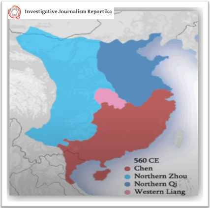
Date: 1271–1368 AD
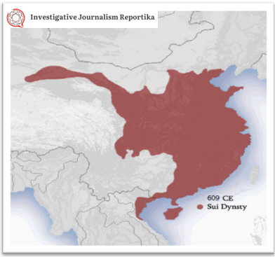
Date : 581–618 AD
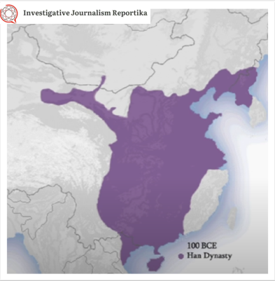
Date : 202 BC – 9 AD; 25–220 AD
Date: 1600 BC- 1045 BC
Download the complete report to get the maps of all the dynasties: Link
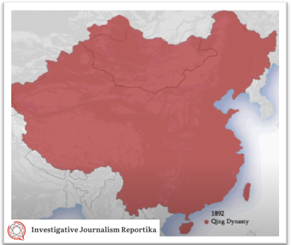
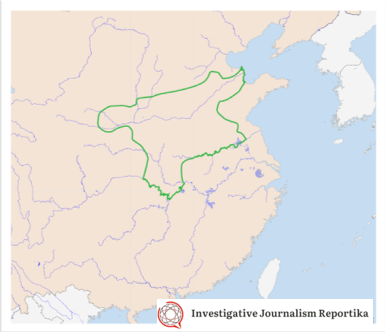
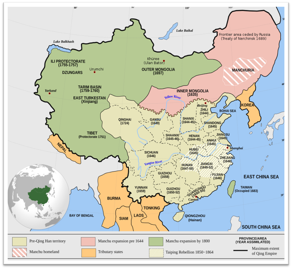
Qing Dynasty
Date: 1636–1912 AD
This map, often referenced by China as a historical source highlighting the largest Chinese empire omits contested territories that China claims in Bhutan, Nepal, India, and the South China Sea (indicated by the “nine-dash line”).
The Context of Distorted Maps
Date : 2023
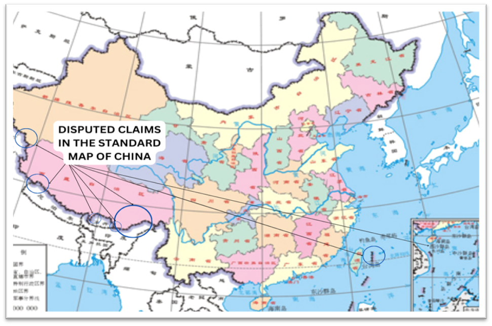
Standard Map Released by China
In 2023, China released an updated map, strategically timed during the “National Mapping Awareness Publicity Week.” This map, hosted on the Ministry of Natural Resources’ cartographic service website, extends territorial claims along China’s western border with India, the South China Sea, and Taiwan. The inclusion of a “ten-dash line” around the South China Sea and Taiwan further complicates maritime disputes, hinting at broader geopolitical maneuvers, especially in the context of China’s rivalry with the United States. The Philippines, Malaysia, Taiwan, India, and Vietnam have rejected the map as baseless. In response to widespread rejection by numerous nations, China asserted that its maps should be considered with a rational and objective lens as it sought to justify the demarcations
Read Investigative Journalism Reportika Report on Chinese Dubious Maritime Activities and Distant Water Fishing (DWF) to assert its claims in the South China Sea in the report: An Investigation into the Dubious Chinese Distant-Water Fishing Fleet (DWF)
Country-Specific Case Studies
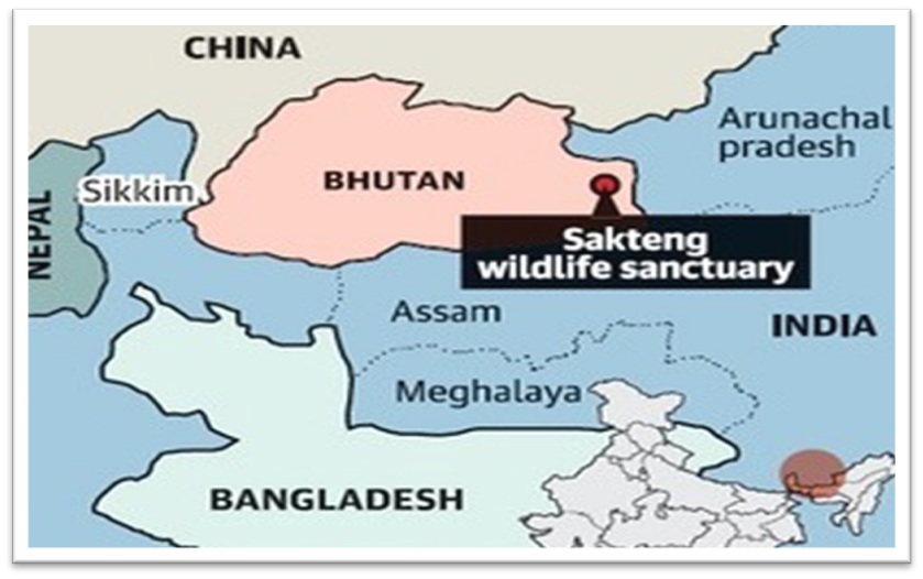
What is the disputed area between China and Bhutan?
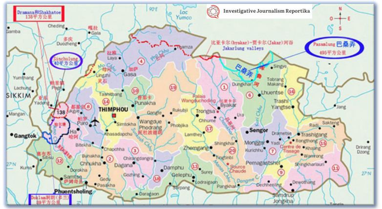
Date : 2020
Map of Bhutan with parts claimed by China
China’s historical claims over Bhutan date back to the 1950s, with territorial disputes over areas like Doklam and Sinchulung. Recently, China asserted a territorial claim over the Sakteng Wildlife Sanctuary in Bhutan as well, contending that it falls within disputed areas between the two countries. This claim was brought to attention during a UNDP-led Global Environment Facility (GEF) conference in June 2020, where China attempted to halt funding for the sanctuary.
Date : 2006
The area including Sakteng Wildlife Sanctuary made news in June 2020 when the Chinese government reaffirmed that it is a territory disputed between China and Bhutan. Bhutan rejected the assertion and denied that China had ever laid claim to the area in the past.
The surprising aspect of China’s claim is its suddenness, as it had not previously objected to such funding and the fact that the Trashigang area, where the sanctuary is located, does not share a border with China.
Which are the disputed areas with Nepal?
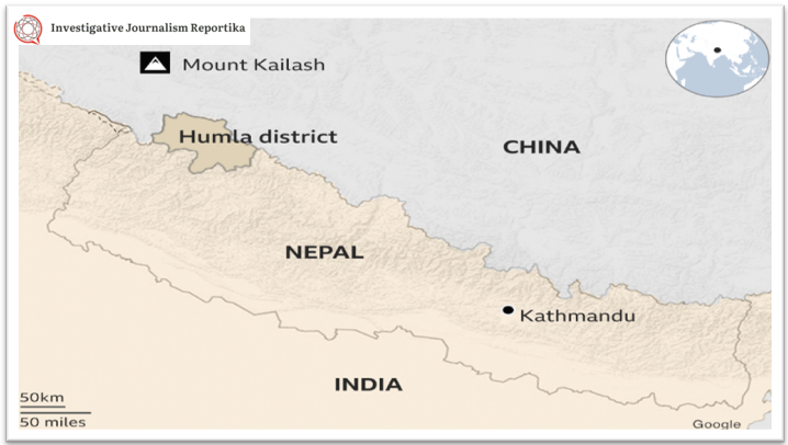
Date : 2022
China encroaching along Nepal border- Report.
Courtesy : BBC
In the past, there were allegations of Chinese encroachment into Nepal’s Humla district, marking the first-ever claims of Chinese incursion into Nepalese territory. Additionally, Chinese state media had asserted that Mount Everest falls inside Chinese territory in the region of the Tibet Autonomous Region.
These past incidents raised concerns about security and geopolitical motives, shedding light on the potential weaponization of maps in the geopolitical landscape.
What are the areas of conflict between India and China?
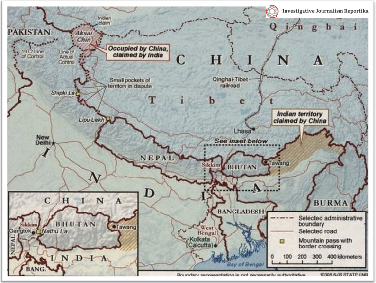
Date : 2006
Line of Actual Control between China and India (Map by the CIA).
The enduring border dispute between India and China is a deeply rooted and multifaceted issue, with historical origins dating back to the 19th century. This ongoing challenge has evolved, shaped by a complex interplay of historical events, diplomatic agreements, and geopolitical shifts. To unravel the layers of this intricate matter, let’s delve into a summary of its key points, providing insight into the complexities that continue to shape the dynamics between these two nations.
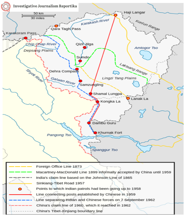
Date : 2020
The map shows the Indian and Chinese claims of the border in the Aksai Chin region, the Macartney-MacDonald line, and the Foreign Office Line, as well as the progress of Chinese forces as they occupied areas during the Sino-Indian War.
In the Aksai Chin region, the Johnson Line, proposed by the British, placed Aksai Chin in India. Tensions escalated in the 1950s when China built a road through Aksai Chin, sparking the 1962 Sino-Indian War with clashes in Aksai Chin and Arunachal Pradesh. China occupied Aksai Chin, ignoring the historical Johnson Line, while India continued to claim it. Arunachal Pradesh, claimed by India but disputed by China, is a source of occasional incursions and tensions. The McMahon Line, drawn by the British, placed Arunachal Pradesh in India, but it was not signed by China.
Read the entire report to understand which area of India is disputed with China: Link
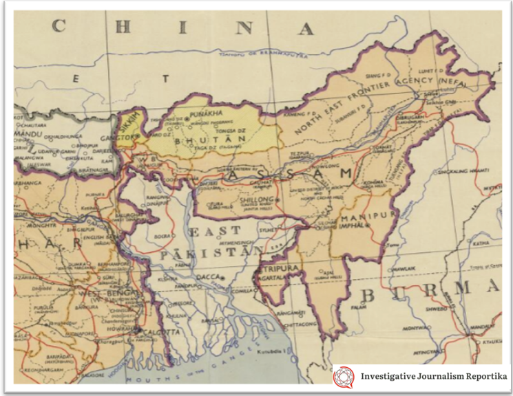
In the eastern sector border, China claims the entire Arunachal Pradesh, considering it a part of Tibet, and occasional incursions and tensions are reported along the border. The India-China border, including areas in Ladakh and Sikkim, has witnessed occasional military standoffs beyond the Line of Actual Control (LAC). Negotiation attempts have not yielded a definitive solution, and tensions persist, as demonstrated by the Doklam incident in 2017. Historical complexities, with China’s disregard for agreements made during the British-India era, add a layer of tension to this complex issue.
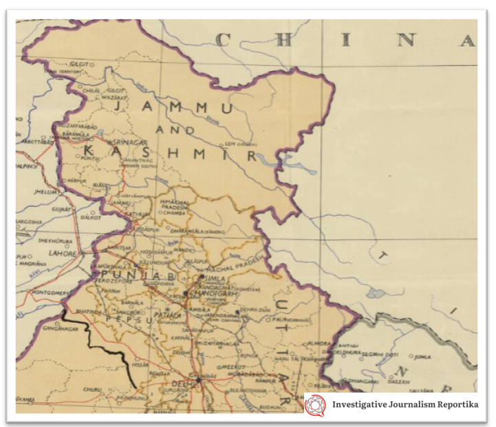
Date : 1954
The Political maps of India was published under the direction of the Surveyor General of India in 1954. IT shows parts of Arunachal Pradesh and Aksai Chin as parts of India.
| SN | Disputed Area / Sector (Alternate Names) | Chinese Province/Tibet | Indian State/UT | Operational Control |
| 1 | Trans-Karakoram Tract (Shaksgam) | Xinjiang | Ladakh | China |
| 2 | Aksai Chin | Xinjiang and Tibet | Ladakh | China |
| 3 | Demchok / Dêmqog (Demchok sector) | Tibet | Ladakh | India / China |
| 4 | Chumar North | Tibet | Ladakh | India |
| 5 | Chumar South | Tibet | Ladakh | India |
| 6 | Kaurik (Sumdo) | Tibet | Himachal Pradesh | India |
| 7 | Tashigang-Shipki La (Khab and Namgia) | Tibet | Himachal Pradesh | India |
| 8 | Jadh Ganga Valley (also Mana Pass) | Tibet | Uttarakhand | India |
| 9 | Bara Hoti | Tibet | Uttarakhand | India |
| 10 | Part of Arunachal Pradesh (especially Tawang) | Tibet | Arunachal Pradesh | India |
| 11 | Upper Siang | Tibet | Arunachal Pradesh | India |
| 12 | West Siang | Tibet | Arunachal Pradesh | India |
Is Tibet a country or part of China?
China’s annexation of Tibet involved a complex historical narrative that we can understand through Chinese maps throughout history. While Tibet had periods of independence, control by the Mongol Empire, and a subsequent era of independence, the situation changed in the 18th century when the Dzungar Khanate occupied Tibet. A Qing dynasty expeditionary force intervened, bringing Tibet under Qing rule in 1720. The region remained under Qing control until the dynasty’s fall.
Fast forward to 1959, tensions between the People’s Republic of China (PRC) and Tibet led to the 14th Dalai Lama’s exile to India. China’s subsequent annexation of Tibet triggered waves of Tibetan refugees and the establishment of Tibetan diasporas globally. In the contemporary context, China’s claim to Tibet has taken an intriguing turn. China released an updated map in 2023, incorporating contested claims, including those over Tibet, the South China Sea, and Taiwan.
You can read about the struggle of Dalai Lama in our report : The struggle for a free Tibet and His Highness Dalai Lama.
Here is a series of Maps that shows how status of Tibet changed over the years.
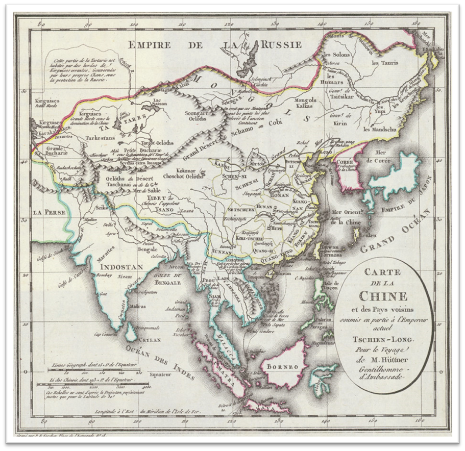
Date : c1798
Map of China, from: Johann Christian Hüttner: Voyage dans l’intérieur de la Chine et en Tartarie fait dans les années 1792, 1793 et 1794 par lord Macartney., Paris, J. J. Fuchs, „an 7“ (1798–1799)
Date : 1820
Attributes: https://commons.wikimedia.org/wiki/User:Philg88
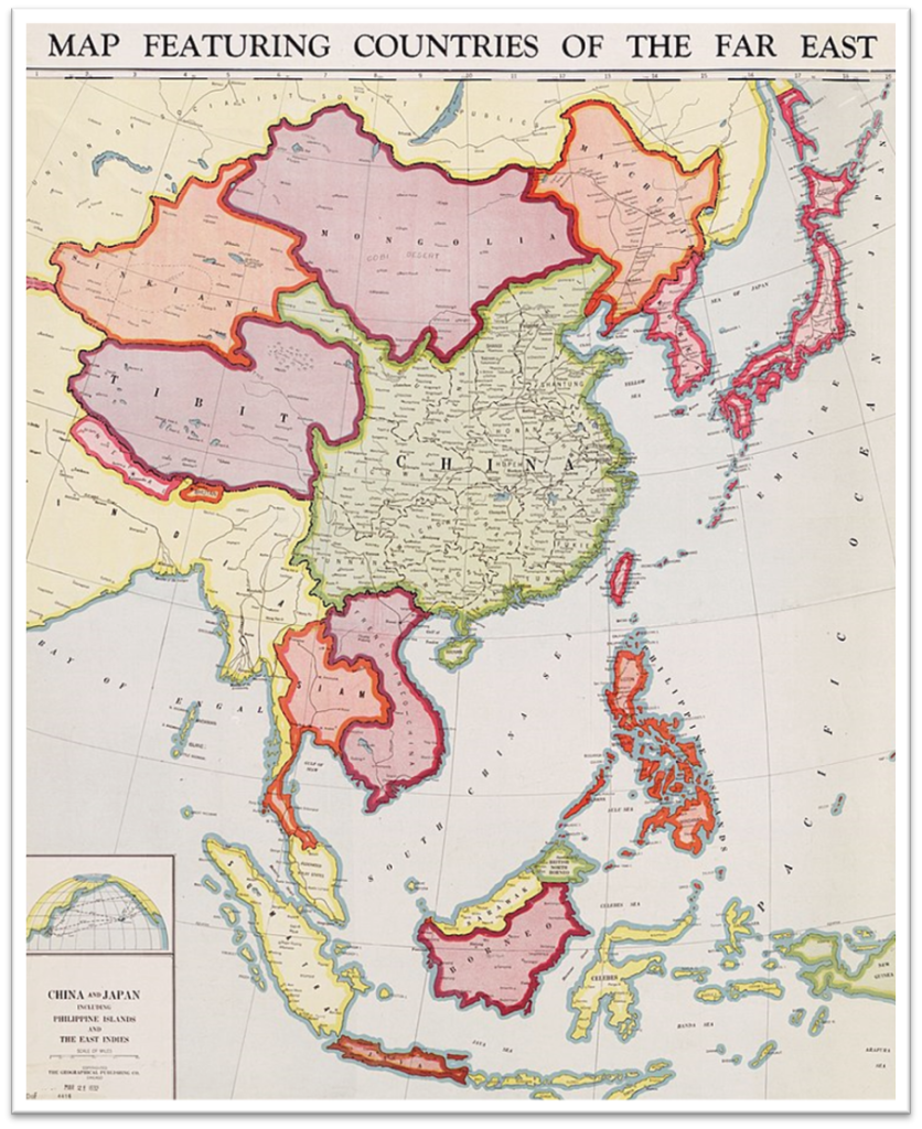
Date : 1932
Attributes: Chicago : Geographical Publishing Co., [1932]
Download the complete report to get the answer to the question “Was Tibet ever under China?”: Link
What is the line with 10 dashes?
The ‘nine-dash line’ is a contentious maritime demarcation in the South China Sea, representing China’s expansive territorial claims. It is more than a simple boundary, signifying sovereignty over islands and maritime zones. Initially ambiguous, it has evolved to become emblematic of China’s influence in the region. The 2023 update, now a ‘ten-dash line,‘ adds to tensions, including Taiwan. As nations reject these claims, understanding the ‘nine-dash line’ is crucial for navigating complex international dynamics in the South China Sea.
Download the complete report to get the 9 Dash and 10 Dash Line: Link
What is the dispute between Japan and China?
Japan-China territorial disputes over the islands in the East China Sea, known as the Diaoyu Islands in the People’s Republic of China (PRC), remain a longstanding and complex issue. China asserts its claim to the islands based on historical evidence, contending that the Diaoyu Islands have been an integral part of Chinese territory since ancient times. China points to historical records from the Ming and Qing dynasties, asserting that the islands were first discovered, named, and used by the Chinese people.
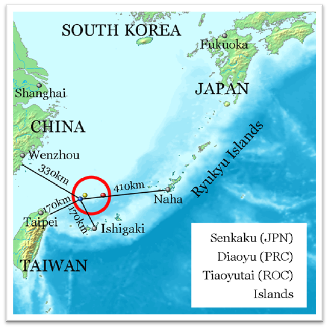
Date : 2013
Referenced on Geospatial Information Authority of Japan and distances referenced on Ministry of Foreign Affairs of Japan.
Contrary to China’s claims, Japan asserts its sovereignty over the islands, referred to as the Senkaku Islands, challenging China’s historical narrative. Japan rejects the assertion of terra nullius by China and maintains that the islands were lawfully incorporated into Japanese territory following the First Sino-Japanese War in 1895. Japan refutes China’s arguments regarding the period of 1945 to 1972, asserting its valid administration of the islands under U.S. control.
Taiwan, officially the Republic of China (ROC), also claims sovereignty over the disputed islands, referring to them as the Tiaoyutai Islands. The ROC asserts historical connections to the islands predating the First Sino-Japanese War and emphasizes their inclusion in maps, official documents, and historical records. Similar to the PRC, Taiwan rejects Japan’s claim of terra nullius and contends that the islands were unlawfully seized.
Conclusion
In the tumultuous arena of geopolitical disputes, China’s deliberate distortion and weaponization of maps to assert territorial claims stand as a stark testament to the intricate dance of power and historical revisionism. As the world navigates through these contentious waters, it becomes abundantly clear that simplistic narratives cannot encapsulate the complexities at play. The strategic use of distorted maps, coupled with the geopolitical weaponization orchestrated by China, demands a nuanced and informed response from the international community.