
Historically speaking, China has claimed the majority of the South China Sea as part of its territory which includes the Paracel Islands, Spratly islands, Pratas Island, Vereker Banks, Macclesfield Bank, and the Scarborough shoal. All these places fall under the much disputed “nine-dash line” markings which are based on a 1947 map. In 1946, a map having eleven dashes or dots was published by the Chinese government. However, two dashes in the Gulf of Tonkin were later removed when a treaty was signed with Vietnam. Many of the Chinese neighboring states including Malaysia, the Philippines, and Vietnam have tried to claim these lands as their own, rejecting the questionable map.

The main issue with the “nine-dash line” lies in the fact that it is an arbitrary collection of dashes without specific coordinates. Based on this map, China asserts rights to more than 80% of the South China Sea. Any official explanation regarding its origin or even its precise delimitation has never been provided by China. On top of that, the regions claimed by China as part of its territory directly lie in conflict with Exclusive Economic Zones (EEZ) of multiple countries in the area like Brunei, Vietnam, Indonesia, Malaysia, Taiwan, and the Philippines.

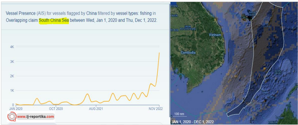
Despite protests by these countries, China has deployed its distant-water fishing fleet in the EEZs of Vietnam and the Philippines. According to data reported by IJ-Reportika, China has fished for over a million hours last year through its Long-liners, Tuna purse seines, Squid jiggers, and Trawlers. While the Chinese DWF activities are not very significant in the South China Sea, overfishing and climate change have led to the depletion of marine resources in the area. Since 2000, the catch rates have declined by 70% and large fish stocks have depleted by 90% in the region. Despite the declining marine resources in the region, it is surprising that Chinese activities have increased in the area while banning the fishing activities of other countries in the region.
Every year since 1999, China imposes a ban on fishing activities from May to August in the area including the Gulf of Tonkin and Paracel islands which are disputed territories. Vietnam condemned this ban and released a statement saying, “Vietnam requests China to respect Vietnam’s sovereignty over Paracel islands…without complicating the situation towards maintaining peace, stability, and order in the East Sea.”

The Philippines has shown contempt for the ban saying “This ban doesn’t apply to us. Our fisherfolk are encouraged to go out and fish in our waters in the West Philippine Sea.” Interestingly, this ban does not apply to Chinese fishermen who have an official license to fish in the contested waters.
It is worth noting that the Chinese DWF vessels are not only there to fish but also operate as de facto maritime militias under the control of the Beijing authorities. There have also been reports of construction activities being conducted by the Chinese in the Spratly islands over the past decade. Legally speaking, this area is not a part of China’s territory, but that has not stopped the Chinese from building reefs, islands, and other formations and even militarizing them with ports, runways, and other infrastructure.
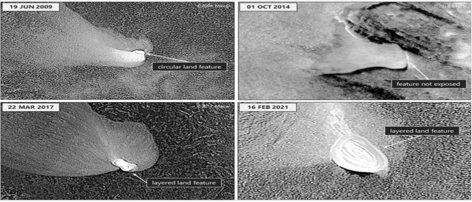
According to multiple media reports and satellite imagery, in the past decade, they have carried out construction activities at four unoccupied features in the Spratly islands. A Chinese maritime vessel was seen offloading a hydraulic excavator which is used in land reclamation projects. It is also reported that new land formations have appeared above water in the Eldad Reef of the northern Spratly islands, which were only exposed during the high tide. The images show large holes, debris piles, and excavator tracks at the site. Similar activities have taken place on Panata Island in the Philippines, where a new perimeter wall was seen around a feature. These activities have resulted in the expansion of some sand bars and other formations in the area by at least ten times.
Although any reclamation activities by China are in direct conflict with the 2016 ruling by the International Tribunal, other nations in the region are forced to undertake their own reclamation work. According to a report by the Asia Maritime Transparency Initiative, Vietnam has expanded dredging and landfill work at several of Spratly outposts and have created roughly 1.7 sq. km of new land in 2022. Following the reports of landfill work and mooring by Chinese ships in the area, the Philippines have also increased their military presence in the region.
As China continues to foray into the disputed waters despite warnings, it is interesting to see the South China Sea through the lens of strategic geopolitical location. With the growing tension in the area, China has been investing more and more in the Navy and coast guard to defend its claim over this territory and increased its presence in the region through fishing fleets. The area could prove to be of significant military importance if the US decided to jump into the regional war, supporting Taiwan’s fight for sovereignty. It is safe to say that China won’t give up control of the region any time soon, even if it means upsetting a few powerful economies.
IJ-Reportika is now in the top 50 Best Investigative Journalism Blogs and Websites
https://blog.feedspot.com/investigative_journalism_blogs/